What is the Ouirgane Valley?
The Ouirgane Valley follows the Nfis river south from Marrakech into the High Atlas, reaching an altitude of around 1,100 metres at Ouirgane village before the road continues to climb towards the Tizi n'Test pass at 2,093 metres. The valley sits between the Ourika Valley to the east and the road to Asni and Imlil to the west — geographically central, but consistently overlooked by tours that go to one or the other.
The landscape is greener and more wooded than most of the Atlas approaches from Marrakech — cedar and holm oak cover the upper slopes, the river runs year-round, and the small farms along the valley floor produce vegetables, fruit and the river trout that the valley restaurants are known for. The overall atmosphere is quieter and more authentically Berber than the more touristy Ourika route.
French travel writers discovered Ouirgane in the mid-20th century and it appeared in several French guides as a weekend destination from Marrakech. That reputation has faded, which is now its main advantage.
The Drive from Marrakech
The route south from Marrakech crosses the flat Haouz plain — agricultural land, olive groves, the occasional roadside café — before the landscape begins to change around Tahanoute at 800 metres. The road from Tahanoute enters the Moulay Brahim gorges and the Atlas proper begins.
Along the way, the small town of Dar Caid Ouriki hosts the most visited market in the valley on Mondays. It is a genuine local souk — not a tourist market — where farmers from the surrounding villages sell produce, livestock and household goods. Worth a 30-minute stop if your timing works.
Tahanoute itself has a Tuesday souk that is one of the larger weekly markets in the region. The square fills from early morning with merchants from across the western Atlas. The contrast with the tourist souks of Marrakech is total.
Moulay Brahim Gorges
Just south of Asni, the road enters the Moulay Brahim gorges — a narrow canyon where the road follows the river through vertical rock walls. The village of Moulay Brahim clings to the cliff above the gorge entrance, built around a 16th-century shrine to a local saint. The shrine is one of the most visited pilgrimage sites in the western Atlas, particularly during the annual moussem festival in spring.
The gorge section of the drive lasts about 20 minutes. The road is narrow but paved throughout. The view looking back down the gorge towards the Haouz plain — with the walls closing in on both sides and the river visible below — is one of the better landscape moments on the drive south.
Ouirgane Village
Ouirgane village sits at 1,100 metres on the banks of the Nfis river, surrounded by walnut trees and small terraced fields. It is a cluster of guesthouses and restaurants rather than a sightseeing destination in the conventional sense — the reason to stop here is to eat, walk, and sit by the river.
The speciality is grilled trout — farmed in the river and served whole, with salad and bread, at the terrace restaurants that extend over the water. It is one of those meals that works entirely because of the setting: the sound of the Nfis, the walnut trees overhead, the Atlas peaks visible above the valley walls. Budget 80 to 120 MAD per person.
Thursday is market day in Ouirgane. The weekly souk is small but genuine — primarily a local exchange of produce and livestock rather than a tourist event. Arriving on Thursday morning adds a dimension to the village that is absent on other days.
The Kik Plateau Hike
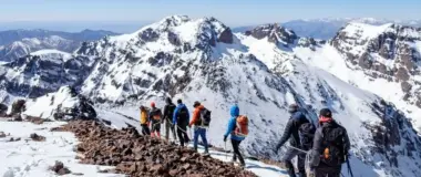
The Kik plateau sits above the Ouirgane Valley to the west — a high limestone plateau at around 1,600 metres with panoramic views across the entire western High Atlas range. Toubkal is visible from the plateau edge on clear days. The Berber villages on the plateau are small and traditional, largely unchanged by tourism.
The route up to the plateau from Ouirgane uses a track that is passable by 4x4 or manageable on foot in about 90 minutes. The track passes through several small farms before opening onto the plateau itself. The view from the edge — looking south over the Nfis valley with the Atlas behind and the Haouz plain in the far distance north — is one of the better panoramas in the western Atlas.
The plateau can also be reached from the Lalla Takerkoust side as part of the Agafay and 3 Valleys day trip. Coming from the Ouirgane side gives a completely different approach and a different perspective on the same landscape.
The Agafay and 3 Valleys day trip combines the Kik plateau with the Agafay desert and the Ourika Valley in a single day.
See the tour →Continuing to Tinmel
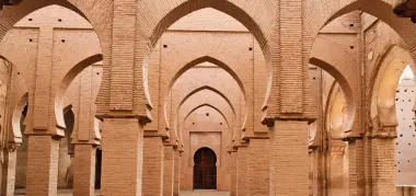
The road from Ouirgane continues south up the Nfis valley to Tinmel — 30 more kilometres and another 30 minutes of driving. The Tinmel Mosque, built in 1156 as the spiritual center of the Almohad empire, sits at the end of this road. It is one of only two mosques in Morocco open to non-Muslims.
Combining Ouirgane and Tinmel in a single day makes excellent use of the drive — the road between them is scenic, the total round trip from Marrakech is about 180 kilometres, and the two destinations complement each other well: one is about food and landscape, the other about history and architecture.
Beyond Tinmel, the Tizi n'Test pass at 2,093 metres is another 20 kilometres — one of the highest paved roads in Morocco and a genuinely dramatic landscape. A full day with a private car can cover Moulay Brahim, Ouirgane lunch, Tinmel, Tizi n'Test viewpoint and a return to Marrakech — arriving around 7pm.
Valley Markets — When to Go
The weekly market calendar in the Ouirgane Valley is one of the most useful planning tools for the day trip. Each souk has a different character:
Monday — Dar Caid Ouriki: The most visited and accessible, about 25 kilometres from Marrakech. Mixed produce and livestock market. Good for a quick stop on the way to Ouirgane.
Tuesday — Tahanoute: One of the larger Atlas souks, held in the main square of Tahanoute at the entrance to the gorges. Farmers, merchants and craftsmen from across the western Atlas.
Tuesday — Amizmiz: A separate market in the village of Amizmiz, 15 kilometres west of Ouirgane on the edge of the Kik plateau. One of the most traditional and least touristic markets in the region.
Thursday — Ouirgane: Small, local, worth timing your lunch stop around if you can.
Practical Information
Distance from Marrakech: 60 kilometres to Ouirgane village, approximately 1 hour 15 minutes by car.
Getting there: No public transport covers this route efficiently. A private car or taxi is the only practical option. A grand taxi from Bab Doukkala to Asni (the closest hub) costs about 30 MAD per seat but leaves you 15 kilometres short of Ouirgane. A private day trip makes more sense for a full exploration.
What to bring: Comfortable walking shoes for the village and any plateau hiking. A layer — the valley is noticeably cooler than Marrakech. Cash for the market and restaurant — no card payment facilities in the valley.
Best season: March to May for green landscape and moderate temperatures. October for clear Atlas views. The valley is accessible year-round — in winter the upper plateau may have snow but the village and lower valley are fine.
Ourika vs Ouirgane: Both are Atlas valley day trips, both are about an hour from Marrakech, both have rivers, Berber villages and mountain scenery. Ourika is more developed, easier, has the Setti Fatma waterfalls and gets significantly more visitors. Ouirgane is quieter, has better food, connects to Tinmel and the Kik plateau, and feels more like the Atlas actually is rather than a curated version of it.